Evidence-led delivery

Featured Geoscience & Engineering Projects

Explore a portfolio of landmark assignments across infrastructure, energy, and construction, where rigorous geological insight has directly underpinned investment decisions and project delivery.

Geological Surveying Geotechnical Assessment Environmental Impact Subsurface Modelling

Technical delivery with measurable impact

PIRAN GEOSCIENCE LTD delivers specialist geoscience and engineering consultancy across the full project lifecycle – from feasibility screening and baseline characterisation through to design development, construction support, and long-term asset management. The projects below illustrate how disciplined data acquisition, transparent interpretation, and robust reporting translate into reduced ground risk and clearer decisions for our clients.

Infrastructure & energy studies completed

120+

Sites with integrated geology–engineering models

80+

Average programme risk reduction

30–50%

A selection of recent assignments where targeted ground investigation, analytical modelling, and clear technical communication have enabled our clients to progress complex infrastructure and development schemes with confidence.

Geoscience field team logging rock exposures along a coastal infrastructure corridor
Integrated field mapping, structural logging, and terrain analysis informing linear infrastructure routing.

Multi-disciplinary geological, geotechnical, and environmental assessment supporting a new strategic transport link.

PIRAN GEOSCIENCE LTD led the ground model development for a 28 km coastal transport corridor in the south-west of England, combining legacy data, targeted field mapping, shallow geophysics, and borehole investigation to de-risk alignment selection in highly variable lithologies.

Scope of work

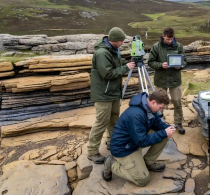
  • Baseline geological mapping and structural interpretation.
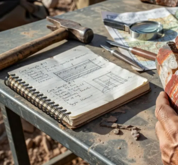
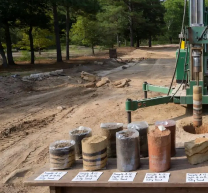
  • Targeted rotary cored boreholes and trial pits along critical sections.
  • Preliminary slope stability and rockfall hazard assessment.
  • Hydrogeological conceptualisation informing drainage strategy.

Measured outcomes

  • 25% reduction in provisional earthworks quantities through route optimisation.
  • Identification and mitigation of previously unrecognised karstic features.
  • Clear evidence base enabling planning consent for the preferred alignment.
Infrastructure Ground Risk Slope Stability
Geological Survey Successes Onshore energy | UK

Regional Geological Survey for Low-Carbon Energy Hub

High-resolution geological characterisation to inform siting and design of a low-carbon energy cluster.

Close-up of labelled rock core samples from a regional geological survey
Systematic logging of core to quantify lithological variability and fracture intensity.

We delivered a region-wide geological survey integrating new cored boreholes, outcrop logging, and desk-based synthesis of historical datasets. Particular emphasis was placed on structural controls, stratigraphic continuity, and geohazard screening relevant to subsurface energy infrastructure.

Methodology

  • Core logging to BS and industry guidance, including detailed discontinuity characterisation.
  • Digital geological mapping with tablet-based data capture and QA protocols.
  • Construction of a 3D conceptual geological model constrained by cross-sections.

Key outcomes

  • Clear definition of stratigraphic targets and exclusion zones for subsurface assets.
  • Evidence-led recommendations adopted as the basis for subsequent geotechnical design.
  • Robust data pack enabling regulators and stakeholders to interrogate the geological rationale.
Geotechnical Assessment Highlights Urban development | UK

High-Density Urban Development – Founding & Ground Movement Assessment

Integrated geotechnical characterisation to support piled foundation design and adjacent asset protection.

For a constrained city-centre redevelopment, PIRAN GEOSCIENCE LTD undertook staged ground investigation and analysis to support piled foundations, basement excavation, and service diversions in highly heterogenous made ground and weak bedrock.

Scope and approach

  • Phase 1 desk study and preliminary hazard register.
  • Phase 2 intrusive investigation with in situ testing and high-quality sampling.
  • Derivation of characteristic geotechnical parameters for design limit states.
  • Ground movement assessment for sensitive neighbouring structures.

Project benefits

  • Refined foundation design leading to a reduction in pile lengths and materials.
  • Transparent communication of settlement risk to stakeholders and insurers.
  • Evidence-based mitigation measures built into construction sequencing.
Environmental Impact Studies Linear infrastructure | UK

Greenfield Bypass – Environmental Geoscience & Impact Assessment

Geo-environmental input to statutory Environmental Impact Assessment (EIA) for a new transport corridor.

We provided the geo-environmental chapter and supporting technical appendices for a new bypass, focusing on soil and groundwater quality, land contamination, mineral resources, and geohazards potentially affecting long-term environmental performance.

Assessment focus

  • Baseline soil and groundwater quality characterisation.
  • Assessment of construction-phase and operational-phase risks.
  • Interface with ecology, hydrology, and materials management disciplines.

Sustainable recommendations

  • Material reuse strategy reducing off-site disposal and import requirements.
  • Monitoring framework to track groundwater and surface water quality.
  • Clear mitigation commitments incorporated into the Environmental Management Plan.
Subsurface Modelling Innovations Energy & utilities | UK

3D Subsurface Model for Strategic Energy Interconnector

Advanced 3D geological and geotechnical modelling to support routing and constructability assessments.

3D subsurface geological model visualisation showing stratigraphy and infrastructure alignment
3D model integrating borehole, geophysics, and geological mapping for route optimisation.

PIRAN GEOSCIENCE LTD developed a 3D subsurface model for a cross-country energy interconnector, combining borehole records, geophysical profiles, legacy reports, and surface mapping. The model provided a single, auditable source of ground truth for multi-disciplinary design teams.

Data integration

  • Standardisation and QA of heterogeneous borehole and trial pit datasets.
  • Incorporation of seismic and resistivity lines to constrain structural geometry.
  • Generation of cross-sections and exportable surfaces for design platforms.

Value delivered

  • Rapid scenario testing for alignment variants and construction methodologies.
  • Improved visibility of geohazards for risk workshops and cost planning.
  • Clear visualisations used to brief project sponsors and regulators.
Site Investigation in Action Industrial | UK

Brownfield Industrial Redevelopment – Targeted Site Investigation

Drilling operations and in situ testing to clarify ground conditions for phased industrial redevelopment.

Drilling rig operating on an industrial site during a geotechnical site investigation
Logistically complex drilling operations executed under live-site constraints.

On a heavily constrained brownfield site, we designed and supervised a phased investigation combining rotary and window-sampling techniques, in situ testing, and groundwater monitoring to de-risk foundations, pavements, and buried services.

Technical rigour

  • Real-time logging and digital data capture with embedded quality checks.
  • Dynamic adjustment of exploratory hole locations in response to field observations.
  • Integration of contamination and geotechnical sampling programmes.

Client outcomes

  • Clear ground zoning allowing phased development with defined risk profiles.
  • Reduced provisional sums for abnormal ground conditions.
  • Concise reporting tailored to both technical and commercial audiences.
Client-Focused Solutions Advisory | UK & Europe

Portfolio Ground Risk Review for Investment Fund

Bespoke advisory support to screen and prioritise ground-related risks across a diversified asset portfolio.

PIRAN GEOSCIENCE LTD supported an infrastructure investment fund with a rapid but technically robust review of ground risks across a mixed portfolio of energy, logistics, and regeneration schemes at varying stages of development.

Consulting approach

  • Structured review of available geoscience and geotechnical information per asset.
  • Risk scoring framework aligned with the client’s internal governance thresholds.
  • Targeted recommendations for additional investigation or monitoring where required.

Feedback

“The Piran team distilled complex ground conditions into a format our investment committee could interrogate quickly, without losing technical substance.” – Investment Director, Infrastructure Fund

Collaborative Scientific Advisory Multi-stakeholder | UK

Scientific Advisory Panel for Major Infrastructure Scheme

Independent, evidence-based input to a multi-disciplinary expert panel overseeing a nationally significant project.

Our consultants contributed independent geoscience and geo-environmental expertise to a formal scientific advisory group convened to scrutinise design assumptions, risk assessments, and monitoring strategies for a nationally significant infrastructure project.

Role and contribution

  • Critical review of ground models, analytical methods, and data quality.
  • Participation in structured risk workshops with designers, contractors, and regulators.
  • Authoring clear, traceable advisory notes and technical memoranda.

Collaborative outcomes

  • Strengthened assurance processes around geoscience inputs.
  • Common understanding of residual risks across stakeholder groups.
  • Enhanced transparency for the public and oversight bodies.
Project Outcomes & Measured Impact Cross-sector | UK

Quantified Benefits Across Recent Commissions

Evidence of real-world value from rigorous geoscience and engineering inputs.

The value of robust geoscience is best demonstrated through measurable outcomes. Across recent commissions, PIRAN GEOSCIENCE LTD has consistently reduced uncertainty, informed safer designs, and supported more sustainable project decisions.

Project focus Key intervention Measured impact
Linear transport scheme Refined ground model and slope stability assessment c. 18% reduction in earthworks costs and improved programme certainty
Urban redevelopment Targeted intrusive investigation and contamination delineation 50% reduction in anticipated off-site disposal volumes
Energy interconnector 3D geological model and geohazard screening Earlier identification of critical risk sections, enabling timely design changes
Industrial brownfield site Ground movement assessment and monitoring strategy Validated protection measures for adjacent strategic assets

Transparent metrics. Wherever possible we express geoscience inputs in terms that directly support investment and programme decisions, whether through quantified cost savings, risk reduction, or enhanced resilience.

Planning a project that depends on getting the ground right?

Discuss how PIRAN GEOSCIENCE LTD can support your next infrastructure, energy, or development scheme – from early feasibility and due diligence through to detailed design, construction support, and long-term asset performance monitoring.

Telephone
+44 73 508 16275
Email
[email protected]
Address
4 The Old Nursery, Malpas, Truro, England, TR1 1GS